you are here » st. joe river homepage » wmp » tasks » task 2 » stream flow gauges

Paw Paw RiverDowagiac RiverSt. Joe at Niles, MISt. Joe at Elkhart, INElkhart RiverAustin LakeSt. Joe at Three RiversSt. Joe at Mottville, MIPigeon RiverSt. Joe at BurlingtonPaw Paw RiverDowagiac RiverSt. Joe at Niles, MISt. Joe at Elkhart, INElkhart RiverPigeon RiverSt. Joe at Mottville, MISt. Joe at Three RiversSt. Joe at Burlington, MIAustin LakeRemove County Lines.

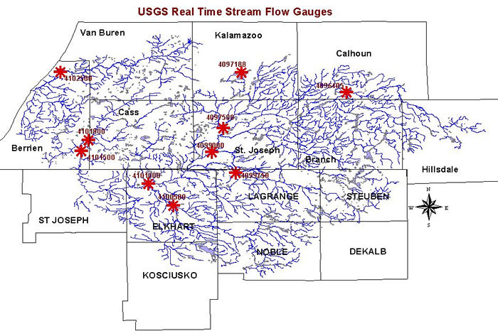
Click on the gauge identification numbers to be connected to the real time flow data for each station. A drop-down menu at the top of each USGS station page labled "available data for this site" will connect you to other available data, such as water quality or mean daily discharge, for that station. The map below allows you to link directly to the mean daily discharge data for stations in the watershed. Print/zoom in on the above map with county lines overlaid (PDF file).

Paw Paw at RiversideSt. Joe at St. Joe, MIPaw Paw near HartfordPaw Paw RiverSt. Joe at Berrien SpringsDowagiac at SumnervilleSt. Joe at NilesJuday CreekChristiana CreekSt. Joe at ElkhartElkhart River at GoshenPine Creek near ElkhartSolomon CreekTurkey CreekPretty Lake InletForker CreekRimmell BranchN. Branch Elkhart RiverLittle Elkhart at MiddleburyPigeon at ScottFawn near W PigeonSt. Joe at MottvilleSt. Joe at Three RiversGourdneck CreekGourdneck CanalPortage RiverLittle Portage CreekNottawa CreekColdwater RiverSt. Joe at BurlingtonSt. Joe near BurlingtonSt. Joe at ClarendonSauk RiverSoap CreekSand CreekSouth Branch HogBeebe CreekPrairie River at NottawaPigeon near AngolaFawn River at OrlandLime Lake at PanamaGourdneck CreekGourdneck CanalPortage RiverLittle Portage CreekNottawa CreekColdwater RiverSouth Branch HogSauk RiverSt. Joe near BurlingtonSt. Joe at ClarendonSoap CreekSand CreekBeebe CreekChristiana CreekJuday CreekTurkey CreekSolomon CreekN Branch Elkhart RiverRimmell BranchForker CreekSt. Joe at BurlingtonPrairie River at NottawaSt. Joe at Three RiversSt. Joe at MottvillePaw Paw RiverPaw Paw near HartfordPaw Paw at RiversideSt. Joe at St. JoeSt. Joe at Berrien SpringsDowagiac at SumnervilleSt. Joe at NilesPigeon at ScottLittle Elkhart at MiddleburyPine Creek near ElkhartPretty Lake InletPigeon near AngolaElkhart River at GoshenSt. Joe at ElkhartLime Lake at PanamaFawn River at OrlandFawn near W PigeonRemove County Lines.

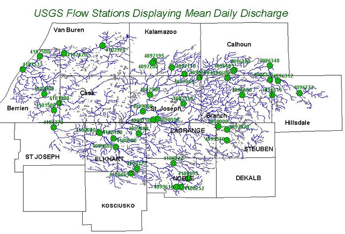
Click on the gauge identification numbers to be connected to the mean daily discharge data for each station. A drop-down menu at the top of each USGS station page labeled "available data for this site" will connect you to other available data for that station. Print/zoom in on the above map with county lines overlaid (PDF file).