 you
are here » st. joe river homepage
» wmp »
tasks
»
task 3 »
nonpoint source load modeling
you
are here » st. joe river homepage
» wmp »
tasks
»
task 3 »
nonpoint source load modeling
you
are here » st. joe river homepage
» wmp »
tasks
»
task 3 »
nonpoint source load modeling
 View
cities and St. Joe River main stem.
View
cities and St. Joe River main stem.
Download a table listing the subwatersheds and their HUC codes:
- as a PDF
- as an Excel file (file contains two spreadsheets: organized by subwatershed code and organized by water course name)
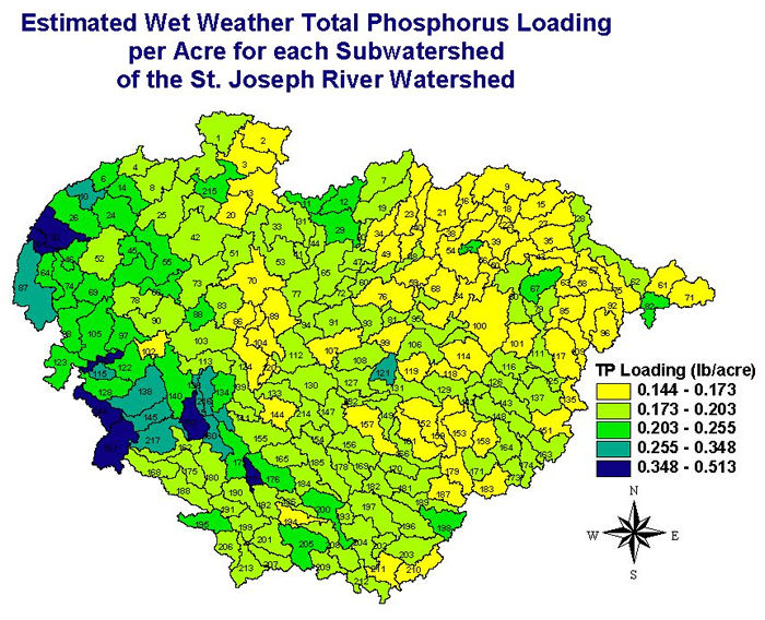
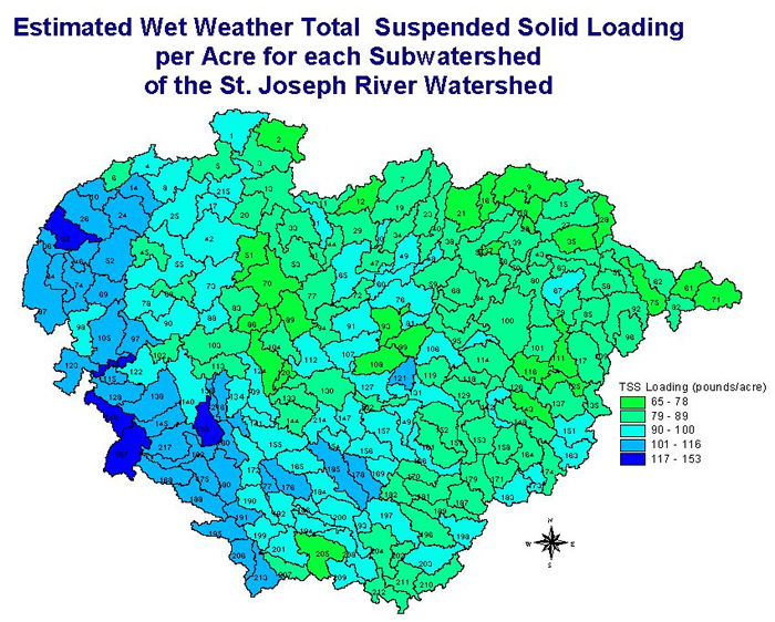
An empirical nonpoint source loading model was utilized to estimate the annual Total Phosphorus (TP) and Total Suspended Solid (TSS) load (in pounds) from each subwatershed in the St. Joseph River Watershed to Lake Michigan. A similar model was utilized for the Kalamazoo River Watershed, to the north. When that model was completed, a 50-year dataset of average annual rainfall data (1949-1999) from 15 weather stations within a 100-mile radius of the Kalamazoo River Watershed was collected. These data were spatially interpolated using kriging, a widely used method of interpolation, to create a continuous grid of precipiation values. Because this grid overlapped the St. Joseph River Watershed, it was utilized for this modeling effort.
By using the precipiation grid and the USGS land cover, an acreage of each land cover type and an annual precipitation depth were calculated for each subwatershed. These data were utilized in a runoff calculation prescribed in the State of Michigan Water Quality Trading Rules to compute an annual runoff volume for each land use type in each subwatershed. These runoff volumes were multiplied by published TP and TSS Estimated Mean Concentrations (EMCs) for each land use type. The EMCs utilized were derived from the Wayne County Rouge River National Wet Weather Demonstration Project (1998). By multiplying the runoff volumes by the EMCs, a TP and TSS load could be calculated for each subwatershed. Those loads were divided by the subwatershed's acreage to produce these TP and TSS maps.
Several coefficients in the runoff equation could be adjusted within a range of excepted values. Additionally, a range of excepted EMCs could be utilized for each land use type. To determine which coefficient values were best to use for this watershed, the model was calibrated with a published tributary loading study (Robertson, USGS, 1997). The author modeled annual loads of TP and TSS from major tributaries to Lake Michigan and Lake Superior. The loads predicted for the St. Joseph River Watershed (773,575 pounds for TP and 136,328 metric tons for TSS) were derived from point source dischargers and nonpoint source loading. Therefore, the annual load from point source dischargers (194,537 pounds for TP and 1,875 tons for TSS) was subtracted from the total. The point source load was derived by averaging the reported discharges from 1990 to 1999. These data were obtained from the USEPA BASINS program. The model was therefore calibrated to yield 557,000 pounds of TP and 134,420 tons of TSS from nonpoint sources.
Additional modeling efforts were conducted for BMP options for:
- urban stormwater, and
- agricultural subwatersheds (SWAT modeling).
Download the report in PDF format.
View the maps of percentage of land use type in each subwatershed.
Urban (commercial/residential/industrial/transportation)
Forest/open
Wetlands
Agriculture
Sources: Robertson, D.M. USGS. Regionalized Loads of Sediment and Phosphorus to Lakes Michigan and Superior: High Flow and Long-term Average. J. Great Lakes Res 23(4):416-439. 1997.
KIESER & ASSOCIATES. Non-point Source Modeling of Phosphorus Loads in the Kalamazoo River/Lake Allegan Watershed for a Total Maximum Daily Load. 2001.
Wayne County Rouge River National Wet Weather Demonstration Project. Urban Storm Water Quantification Protocols. 1998.
USEPA. BASINS. http://www.epa.gov/ost/basins.
 View
cities and St. Joe River main stem.
View
cities and St. Joe River main stem.