 you
are here » st. joe river homepage
» wmp »
tasks
» task 8 » ordinances/planning
for watershed protection
you
are here » st. joe river homepage
» wmp »
tasks
» task 8 » ordinances/planning
for watershed protectionyou
are here » st. joe river homepage
» wmp »
tasks
» task 8 » ordinances/planning
for watershed protection
Link
to table.
Download full text (.doc).
Introduction Task 4, Prioritization of Concerns, resulted in a subwatershed scoring technique which ranked each of the major drainage units and the 217 delineated subwatersheds for their preservation and mitigation potentials. The next step after identifying areas prioritized for various activities is to identify the mechanisms to encourage those activities. Because the watershed is so large, site specific information cannot be gleaned for the entire basin. Instead, land cover data and other spatial data were relied upon to model the watershed at its broad scale. Similarly, protection mechanisms and identification of practices already in place are largely broad, as the identification of specific land use planning activities and ordinances in every municipality was not possible under the scope of this project. Identification of those mechanisms were gleaned from stakeholder interviews and internet research. Therefore, they are not inclusive. Further, the identification of geographic regions to apply these measures are also not inclusive. This chapter should be viewed as an introduction to additional needed work in the implementation phase. (Links to additional information are provided on the attached table.) Preservation of forests and wetlands The subwatersheds were scored based on the percentage of wetland and forest land cover in each. The highest average scores were identified in the northwest portions of the watershed, which include the Paw Paw River, Dowagiac River and Rocky River Watersheds. Beebee Creek in Hillsdale County also scored high. However, this does not indicate that preservation is not important in the Indiana portions of the watershed. An isolated wetland was identified in the Turkey Creek Watershed in the southern portion of Elkhart County. This score was lost in the major drainage unit scoring, but was identified in the scoring of the 217 subwatersheds. The Steering Committee identified sediments, nutrients, habitat loss, wetland loss and animal waste as the top five watershed concerns. The preservation of intact forest, prairie and wetland areas can prevent an increase in the occurrence of those concerns, and other techniques discussed in this chapter can reduce those pollutants at the source. |
||||||||||||
|
||||||||||||
(The Indiana Heritage Trust link in the attached table includes additional information about preserved lands in the watershed.)
|
||||||||||||
|
||||||||||||
|
The Trillium Land Conservancy works to protect land in Elkhart County. The Wawasee Lake Conservancy Foundation has acquired over 419 acres of wetlands around the Wawasee Lake in Noble County. Townships can establish partnerships with land trusts to provide matching funds for fee simple ownership of lands or to purchase conservation easements or development rights. Private landowners can receive tax incentives to protect their own land through conservation easements. A landowner may wish to sell the land to a buyer who has conservation goals for the land. However, it is expensive and time consuming to advertise these lands for sale through special avenues to find buyers. Similarly, it may be difficult for buyers to find large tracts of undisturbed land. A network of buyers and sellers interested in conservation is needed. This network should be used to conserve agricultural lands, as well.
Identification of areas to apply conservation measures/BMPs Agricultural
land
The watershed is largely agricultural (70%). Agriculture occupies over 80% of the land use (by subwatershed) in the Pigeon and Elkhart River Watersheds (Indiana). Agricultural products include hogs, cattle, corn, soybeans, wheat and hay. Some fruits and vegetables are grown in the western portions of the watershed. Traditional farming methods are practiced by Amish communities in the eastern and central portions of the watershed.
|
||||||||||||
|
||||||||||||
|
The Wood-Land-Lakes RC&D Council works to protect farmland in Northeast Indiana. It holds conservation easements on farms in Elkhart, LaGrange and Steuben Counties. Tax Incremental Funding has been used in Elkhart County to provide a rebate on tax increases for the purchase of development rights on agricultural land. The use of this mechanism for agricultural protection was unique because the funds are typically used for industry. The Land Information Access Association (Traverse City, MI) has developed websites for Hillsdale and Van Buren Counties and an informational CD for the Dowagiac River Watershed Project. These resources all contain valuable information on zoning methods to protect farmland including exclusive use zoning, slide scale zoning, open space (cluster) zoning and the requirement of buffers between agricultural land and residential development. (More
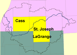
information on these and other zoning techniques can be found on the Land use ordinances including agricultural land protection measures are developed on a township basis. Some Michigan townships have received assistance from the Dowagiac River Watershed Project to prepare new Master Plans. Calvin, Wayne and Marcellus Townships (Cass County) were noted as examples of municipalities with good land use planning in the interview process. Agricultural lands in these townships are zoned as prime or general. Prime agricultural land sold in the townships may only have one residence constructed on every forty acres. (Prime agriculture is defined by the USDA as land best suited to grow food, feed, forage, fiber and oilseed crops. Prime agriculture produces the best yields with minimal economic input and the least environmental damage.) In contrast, general agricultural areas allow smaller parcel divisions. Many of these forty-acre plots are being used for small horse farms. This ordinance has prevented the development of small residential lots in the Christiana Creek Watershed. In contrast, Newburg Township in Cass County has no land use zoning. Agricultural lands can also be protected with open space zoning, which uses cluster development to concentrate homes and leave the remainder of the property undeveloped. Indiana has a filter strip law which allows for a $1/acre assessment for property taxes for farms having filter strips of a particular size. It appears that this would serve as a good incentive for landowners to use this practice. However, many still do not use them. One suggested reason is a reluctance to use federal funding, as the use of funds may include restrictions on property rights. It may be a good idea to incorporate a mechanism to provide mini-grants from the Friends of the St. Joe River Association for the installation of BMPs. Therefore, the direct connection in the funding is from a nonprofit agency, creating a buffer and alleviating potential concerns about infringements on private property rights through federal restrictions.
Lake
communities |
||||||||||||
|
||||||||||||
|
Other requirements to protect lake resources can include a restriction on the installation of septic systems in new developments, which should only be constructed where they have access to the sanitary sewer. The Kalamazoo Metropolitan County Planning Commission recommends this in its policy statements. When a property with a septic system is sold, an inspection should be required. Further, information on proper septic system maintenance should be provided to the new property owner. The Michiana Council of Governments has produced a free educational video titled "Septic Systems 1-2-3". It has been distributed to title companies within the jurisdiction. Wider distribution of this video throughout the watershed to Realtors and title companies should be sought.
Some states allow Clean Water Fund Revolving Loans to be used for nonpoint source pollution reduction projects, including maintenance of septic systems. Funds are traditionally used for upgrades and construction of wastewater treatment plants. This could include the construction of new plants for lake communities. Indiana funds may be used for wetland protection, erosion control, stormwater Best Management Practices and conservation easements. Michigan Revolving Fund monies may only be used for publicly owned facilities, which may include stormwater facilities. The state has created a Strategic Water Quality Initiatives Fund which can be use for the upgrade or replacement of failing on-site systems, or the removal of stormwater or groundwater from sewer leads. According to "Funding Opportunities: A Directory of Energy Efficient, Renewable Energy, and Environmental Protection Assistance Programs" published by the U.S. EPA State and Local Capacity Building Branch (2004), Drinking Water State Revolving Funds can be used in some instances to support green infrastructure activities such as permeable pavement, rooftop gardens and other measures that help reduce the urban heat island effect and save energy. Grants are awarded to states to provide low-cost loans to public water systems to finance the costs of infrastructure projects. States are also authorized to use a portion of their funds for set-aside activities such as source water protection. |