 you
are here » st. joe river homepage
» wmp »
tasks
» task 8 » ordinances/planning
for watershed protection page 2
you
are here » st. joe river homepage
» wmp »
tasks
» task 8 » ordinances/planning
for watershed protection page 2you
are here » st. joe river homepage
» wmp »
tasks
» task 8 » ordinances/planning
for watershed protection page 2
back
to page 1
Link
to table.
Download full text (.doc).
Urban land
|
||||||||
|
||||||||
|
Ordinances regulating the quantity and quality of stormwater can be implemented in urban areas to protect water quality. In Dane County, WI a ban on phosphorus containing fertilizer is being explored to protect sensitive lakes. In 2002, the State of Minnesota passed a bill to allow counties to locally ban phosphorus fertilizers on lawns. In April 2004, The Minnesota House of Representatives voted to make a state-wide mandatory ban. At the time of this writing, the Senate vote was pending. Stormwater utility fees are being used in some communities to fund improvement projects. The fees treat the storm sewer system as a utility provided by the municipality, similar to water and sanitary sewer utilities. Fees are paid by users, i.e., property owners, and are based on the level of use. Fees are determined by property size and amount of impervious surface. Reductions in fees can be sought through the use of measures to reduce runoff, such as use of pervious pavement and rain barrels. To distinguish a user fee from a tax, it must meet certain criteria. It must primarily benefit the user of the utility and not the general public. It must be voluntary, that is, the fee payer must be able to choose to not use the utility. It must be proportional to the service actually used. It must be used for the municipality to meet a regulatory requirement and not for generating revenue.
(The "Authority for Local Stormwater Fees in Indiana" link in the attached table provides guidance to Indiana municipalities wishing to explore stormwater fees.) Post-construction ordinances identify the maintenance practices needed to maintain stormwater utilities. These practices may include street sweeping, cleaning of catch basins and pervious surfaces, visual inspections, monitoring of outflow of retention basins, limits on the use of deicing materials and education of residents regarding stormwater issues. Other suggestions include requiring all general purpose floor drains to be connected to the sanitary sewer. |
||||||||
|
||||||||
|
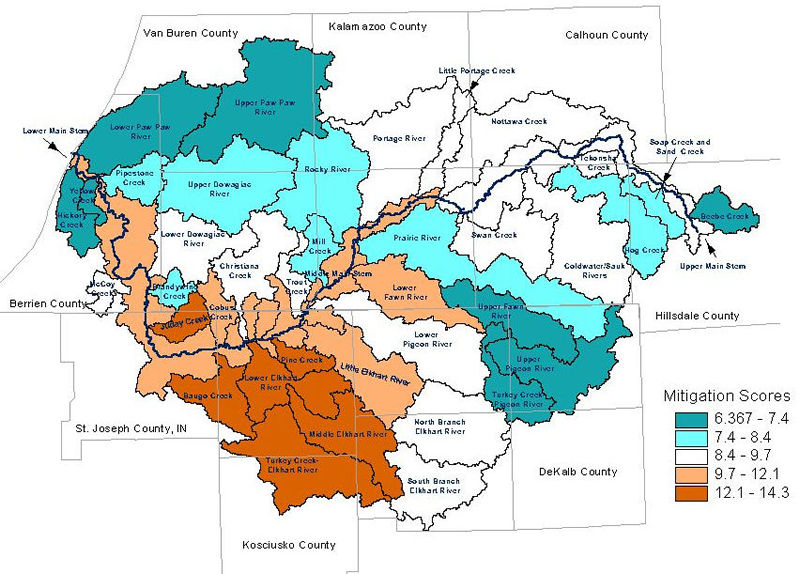
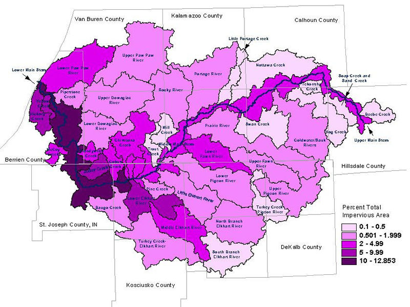
Combined sewer overflows (CSOs) from 12 cities in Indiana and 2 in Michigan impact the water quality of the St. Joseph River.
USEPA Phase II Stormwater Rules are requiring municipalities and educational institutions in urban areas, as defined by the 2000 U.S. Census, to obtain permits for stormwater discharges. The permit process includes a watershed management plan, education/outreach activities and an illicit connection detection and elimination program.
Ordinances for soil erosion and sedimentation are important to minimize runoff from construction sites. The Phase II Stormwater Rules specify that construction activities that disturb one acre or more of land require a stormwater control permit. Noble County adopted a stormwater drainage and erosion ordinance for disturbances greater than one acre in size prior to the update of the Indiana Rule 5, which previously required permits for projects disturbing over five acres, as required by Phase I Stormwater Rules. Erosion control plans should be adjusted as site conditions change or as observations during construction identify on-site needs. Various drawings for different stages of development should be used, as different erosion control measures will be needed at different times. Exposed soil should be vegetated as soon as possible. This may follow rough grading, as opposed to waiting for the whole project to be completed. In areas with storm sewers, inlet protection should be used to prevent soils from entering area surface waters. Site access should be restricted to a minimum number of entry/egress points to prevent tracking of sediment off-site. These points should have stones to shake soils off of vehicle tires or tire washing stations. Soil stockpiles should be covered at the end of each workday.
(Example
language for the ordinances described can be found through the Center
Zoning ordinances typically identify these urban areas as industrial, commercial and residential (single family, multi-family). However, they also allow the surrounding areas to support these land uses. Transportation infrastructure allows this development to move further and further from urban areas into lands previously used for agriculture or supporting valuable habitat. There are many causes and consequences of sprawl that are extensively studies by land planning experts. A Michigan Sea Grant study (2002) of land use planning in coastal communities indicated that Michigan, as a whole, is following a low-density development pattern which is highly land consumptive. The state has one of the highest ratios of urbanized land per person in the country. Traditional zoning allows sprawl to continue unchecked. One cause is that watersheds lie in multiple political jurisdictions, each with its own zoning code. For example, the St. Joseph River Watershed includes over 170 townships in both states. In Michigan, land use planning and zoning falls to the authority of each township, some of which lack monetary resources to protect their valuable natural features. In Indiana, land use planning is conducted at the county level, which allows more broad recommendations to be implemented. However, site specific details and needs of constituents can be lost, similarly to watershed planning at the large scale. |
||||||||
|
||||||||
|
||||||||
|
These communities may also use incentives or requirements for individual on-site measures, such as rain gardens or rain barrels. The community includes open space to be used as parks, stormwater treatment or habitat. For example, long shallow vegetated depressions can be dug in open areas for stormwater infiltration. During dry weather, they appear to be a part of the landscape. Low impact development saves money for developers through a reduction in the amount of roads, sidewalks and storm sewers, which can amount to ½ half the cost of the subdivision. The Kalamazoo Metropolitan County Planning Commission Policy Statements (1999) encourages Planned Unit Developments and discourages the development of residential property units in rural areas. A municipality can provide density bonuses to developers who protect open space and keep development away from sensitive areas, which should be preserved as assets to the property. Protection of the watershed as a whole Watershed management planning should also include mechanisms to consider and protect the watershed as a whole. Currently, the Indiana portion of the watershed is considered in planning decisions through the St. Joseph River Basin Commission, which was established by the Indiana General Assembly in 1988 (Indiana Code 14-30-3). It includes representation from municipalities and counties within the watershed and the Indiana Department of Natural Resources. A formal mechanism within the Michigan portion of the watershed or across the watershed boundaries would be beneficial to the watershed. The watershed also has regional planning commissions, such as MACOG, the Southwest Michigan Commission (Region 4) and the South-Central Michigan Planning Council (Region 3). However, it does not appear that these commissions work together on a watershed basis. There are examples of multi-state watershed commissions throughout the nation. For one, the Connecticut River Joint Commissions were created in 1989 by combining New Hampshire's Connecticut River Valley Resource Commission, created by legislature in 1987, and Vermont's Connecticut River Watershed Advisory Commission, similarly created in 1988. The role of the commissions is advisory to assure public involvement in the protection of the river and valley. Some multi-state watersheds, such as Lake Champlaign, have been assigned special designations. Others, like the Chesapeake Bay Watershed, have become the focus of divisions of the U.S. Environmental Protection Agency (USEPA). The USEPA has encouraged the use of watershed based NPDES permits to monitor and reduce pollutant loading. These have been done in the context of a TMDL and may have application with the St. Joseph River E. coli TMDL. With these permits, point sources are regulated collectively to meet a maximum load to the river. Watershed based permits have been used for nutrients in the Long Island Sound, CT; the Neuse and Tar-Pamlico River, NC; and the Tualatin River, OR. A general stormwater permit is available for all watersheds in the State of Michigan. This process stemmed from the court-mandated cleanup of the Rouge River. The permit is available as an alternative to the traditional six minimum measures permitting option under the Phase II Stormwater Program. The Ohio River Valley Sanitation Commission (ORSANCO) was established in 1948 to control and abate pollution in the Ohio River Basin. ORSANCO is an interstate commission representing eight states and the federal government. Member states, including IN, IL, KY, NY, OH, PA, VA, WV, entered into a compact to establish the commission. The Miami Conservancy District was established in 1913 in response to a devastating flood. It is a political subdivision of the State of Ohio that provides flood protection and water resource monitoring for the Great Miami River Watershed in Ohio and Indiana. The State of Ohio has 23 conservancy districts, all organized at the watershed level. The Tip of the Mitt Watershed Council works to protect watersheds in Northern Michigan. It administers the Great Lakes Aquatic Habitat Network and Fund. The Network has a hub in each Great Lakes state which provides information and assistance on issues within the Great Lakes portion of that state. The Fund provides small grants to grassroots organizations to install BMPs and protect local water resources. Short of a special designation or commission, a permanent watershed coordinator position should be funded to assure continued work to protect the watershed. Funds could come from watershed assessments (as a part of property taxes), membership dues to the Friends organization or grant funding, such as the grant which supported this project. |
||||||||